Earth with Magnetic Field Visualization
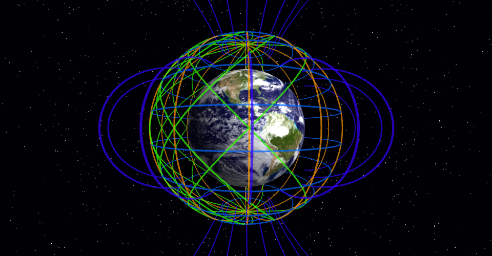
This project shows a 3D visualization of Earth with its magnetic field represented by field lines.
Features
- 3D Earth with realistic texture
- Complete 360° magnetic field visualization:
- Latitude field lines (horizontal circles at different heights)
- Longitude field lines (vertical semicircles connecting poles)
- Diagonal field lines for complete spherical coverage
- Traditional dipole field lines for scientific accuracy
- Interactive camera controls (rotate, zoom, pan)
- Earth rotation animation
- Starry background
Technologies Used
- Three.js for 3D rendering
- JavaScript ES modules
- HTML5 and CSS
How It Works
The magnetic field is visualized using a comprehensive set of field lines:
- Latitude lines encircle the Earth horizontally at different heights from pole to pole.
- Longitude lines connect the north and south poles vertically along meridians.
- Diagonal lines connect various points on the field sphere for complete coverage.
- Traditional dipole field lines follow the r = C * sin²(θ) formula, connecting the magnetic poles.
Together, these lines create a complete visualization of a magnetic field surrounding the Earth in all directions.
The blue marker indicates the north magnetic pole, and the orange marker indicates the south magnetic pole.
MIT Licensed